Downscaling of Climate Change Projections
Translating Global- to Local-scale Climate Scenarios for Critical Planning Efforts and Decision Making Under Uncertainty
It is now unequivocal that anthropogenic climate change presents substantial uncertainty to society. It shapes important decisions about the design, location, construction, and operation of key cross-sectoral infrastructure and resource planning and ways to reduce their vulnerability and risks to extreme weather. Risks related to this climate uncertainty has grown as the 21st century progresses. But how do project managers, professionals and communities plan for uncertain climate change magnitudes and timelines? This challenging question often leads to adoption of a “wait and see” holding pattern. However, postponing an honest assessment of climate change risks and assuming a “business-as-usual” approach to planning is a risky proposition. There is no time like the present to begin factoring practical climate change considerations into cross-sectoral decision making, even considering uncertainty in the magnitude of future change.
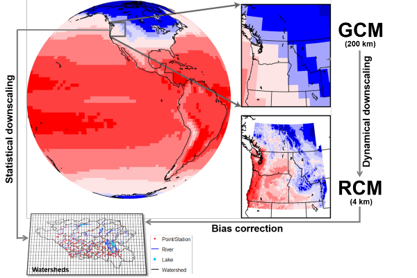
As the climate changes, it is likely that risks for infrastructure and ecosystem failure will increase, particularly in northern regions, due to shifting weather patterns and extreme weather conditions becoming more variable and regionally more intense. Communities’ ability to adapt to climate change requires specific information on how local changes in key variables such as temperature, precipitation and windspeed will play out locally, how these expected changes may vary throughout the seasons, and about new climate extremes and their interaction with key assets. Such projections are generally based on numerical global climate model (GCM) simulations at coarse scale (70–400 km). But site-specific projects typically require finer scale climate data to understand climate change impacts. For use in practical applications, these projections need to be downscaled (and bias-corrected) to local scale, either statistically or dynamically (e.g. Weather Research and Forecasting Model—WRF). Statistically downscaled climate scenarios data can reproduce local climate extremes such as heat waves, droughts, and cold spells. However, many other types of high-impact extreme events such as convective precipitation, floods, and windstorms are by nature small scale and physically based. Statistically downscaled data often leads to unrealistic physical climate characteristics and may not capture these community-scale weather and climate processes (e.g., precipitation intensity, high wind gusts and windspeeds) necessary to identify existing and emerging hazards.
CLIMALOGIK’s science-led expert team of leading climate modellers, climatologists, hydrologists, data scientists, statisticians and numerical modelers allows us to deliver scientific insights, impact, and high-resolution practical climate scenarios data to support our clients’ unique engineering design needs and priorities. From translating climate scenarios to local scale through downscaling, we analyze project-site specific future climate information, assess the validity and representativeness of these data, and interpret them into climate parameters for climate impacts, risk, and vulnerability modeling on human and biophysical systems in support of our clients’ strategic decision-making.
Our areas of expertise include:
- Downscaling of Site-specific Climate Projections
- High-resolution Regional Climate Downscaling
- High-resolution Modelling of Weather and Future Climate Extremes
- Bias Correction of Climate Projections
- Uncertainty Analysis of Climate Projections
- Calculation of Sector-relevant Climate Indices
- Statistical Analysis of Large, Multidimensional Climate Change Datasets
- Quantifying Changes in Climate Variability and Extremes