

10
climate hazards assessed
23
climate indices, two emissions scenarios
3
time periods: baseline, 2050s and 2080s
275+
participants, including First Nation communities
The question
New Brunswick had no province-wide picture of climate risk. The Climate Change Secretariat needed to know which climate hazards pose the greatest risks, how those risks grow by mid and late century, and where adaptation planning should start.
What we did
We provided the climate science for the assessment, led by the Climate Risk Institute. We selected the emissions scenarios and the climate model ensemble, assembled 23 climate indices from ClimateData.ca and PCIC for a moderate (SSP2-4.5) and a high (SSP5-8.5) emissions scenario, added published projections for sea level, storm surge, freezing rain and wind, and scored the likelihood of each hazard on a 1 to 5 scale for the baseline (1981 to 2010), the 2050s and the 2080s. Those likelihood scores fed the risk ratings across the assessment’s five Focus Areas, from public health and safety to physical infrastructure.
- CMIP6 projections
- Climate indices
- Likelihood scoring
What New Brunswick received
- Climate projections for a moderate and a high emissions scenario, for the baseline, 2050s and 2080s
- A climate summary of 23 climate indices, seasonal temperature and precipitation projections, and published projections for sea level, storm surge, freezing rain and wind
- Likelihood scores for every hazard and time period, used to rate each risk
- The projected climate trends published in the Summary Report and the Technical Report
What changed
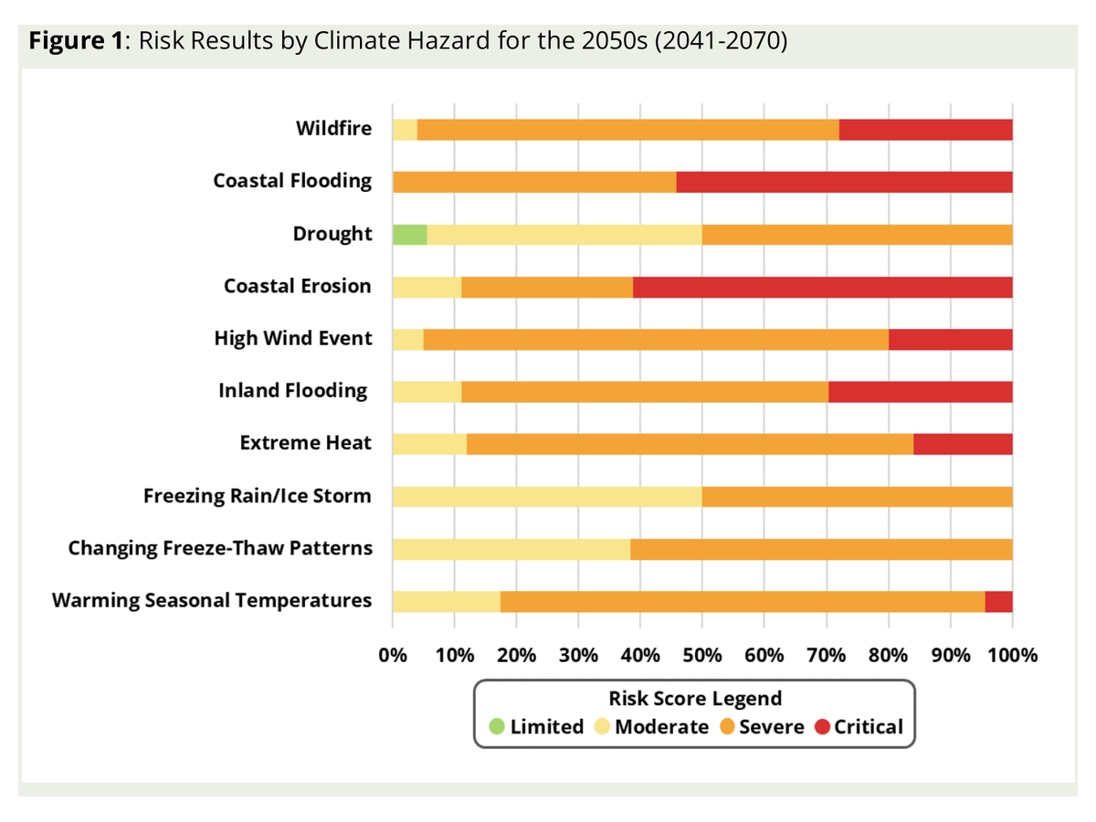
In February 2026 the Government of New Brunswick released the province’s first climate change risk assessment. It finds that coastal flooding and erosion, inland flooding and wildfire drive the most critical risks by the 2050s, with extreme heat emerging by the 2080s. It lays the foundation for prioritizing adaptation across government, communities and sectors.
What the projections show
- Winters up to 6.7 °C warmer by the 2080s
- 30% more days with over 20 mm of rain by the 2050s
- Hot days over 30 °C nearly 7 times more often by the 2080s
- A wildfire season 17 days longer by the 2050s
- Relative sea level up more than 1 metre by the 2080s in some areas
High emissions scenario. Source: New Brunswick Climate Change Risk Assessment, Summary Report (2026).
Related service
We provide the climate science behind the risk ratings: projections, climate indices and likelihood scores your risk team can use.
Discuss your project
Start with a 30-minute call with a climate scientist about your question, your data and your timeline.